Digital winter service
Digital tour planning

route planning in winter service

Easily plan gritting and snow clearing

Small time windows, individual customer requests and different requirements for deployment teams and machines can quickly turn the planning of winter service operations into a complex task.

With geoCapture's digital route planning, optimum deployment plans for winter service can be created in no time at all efficiently.

Optimum pre-planning of clearing jobs

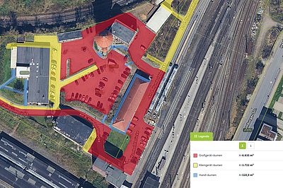
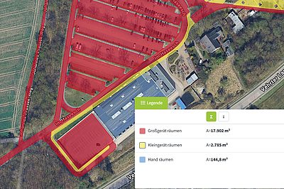
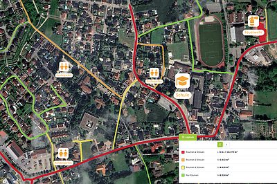
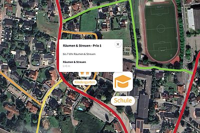
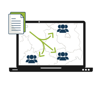
With geoCapture route planning, your routes are pre-planned in a cost-optimized manner. The system automatically distributes the jobs to several teams. Standard routes and schedules are created in the route planning. These can be easily saved and called up when needed. Ideal routes and an optimal distribution are created even with a large number of locations (properties) and teams. The route plans are created on Google Maps. These are stored as a plan / order document.

App for order execution

The geoCapture app serves as a means of communication between the dispatcher and the driver. The driver is navigated to the object via the app. All plans and documents relating to the order are also stored there. As soon as the job has been completed, the employee submits a completion report via the app. The work carried out is documented via smartphone. Photos and a digital signature can be added.

Seamless access to properties

Unhindered access to properties and land is important for a smooth winter service. It is fatal if the emergency team only realizes on site that a key is not on board. This inevitably leads to delays.

Digital key cabinets, such as those from ECOS, offer an optimal solution. Forget the key chaos. The cabinets control access to the keys and log their use. This means that all keys are on board for the execution of a tour and your teams have access to all properties.

Create digital site plans directly in geoCapture

miamapo in winter service

Classic route planning is often not enough for winter road maintenance. While routes are easy to plan, sidewalks, parking lots and complex areas have completely different requirements for planning and execution.

This is exactly where miamapo expands the possibilities of geoCapture. miamapo is a map-based editor with which you can digitally create and manage deployment areas, site plans and clearing concepts. These are displayed directly on the digital map and are comprehensible for everyone involved. You simply add the map sketch to your project or order or import existing miamapo maps without having to leave the geoCapture portal.

Digital area recording

With miamapo, you can record all relevant areas of use directly on the map. Parking lots, sidewalks and access roads are precisely delineated using geofences. Additional information allows you to set priorities and define special features of individual areas.

Precise area calculation

miamapo automatically determines surface areas, lengths, perimeters and volumes. This data forms the basis for the exact calculation of material requirements. Without a digital area solution, areas often have to be laboriously determined on site. This step is completely eliminated.

Sound quotation preparation

You can share the miamapo map with your client via a link as early as the quotation phase. Your client can see exactly which areas will be taken into account for clearing and spreading. In this way, a quotation is not just a price quotation, but a visually verified and jointly agreed performance basis.

Visual resource planning

Your resource planning is no longer done using tables, but directly on the map. Your employees immediately gain a clear understanding of complex objects and maintain an overview even in large areas. miamapo enables intuitive and structured planning for all employees.

Request a quote now!

Enthusiastic? Start now with your individual route planning for winter service.

Request a quote